Our website is made possible by displaying online advertisements to our visitors.
Please consider supporting us by disabling your ad blocker.
Athabasca Sand Dunes Provincial Park
| Athabasca Sand Dunes Provincial Park | |
|---|---|
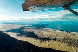
 Flyover of the sand dunes | |
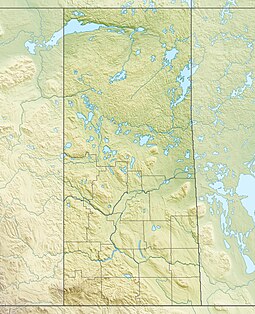
Location of Athabasca Sand Dunes Provincial Park in Canada | |
| Location | |
| Nearest city | Uranium City |
| Coordinates | 59°03′47″N 108°57′44″W / 59.06306°N 108.96222°W |
| Area | 1,925 km2 (743 sq mi) |
| Established | August 1992 |
| Governing body | Saskatchewan Parks |
 | |

Athabasca Sand Dunes Provincial Park was created to protect the Athabasca sand dunes, a unique boreal shield ecosystem located in the far-northwest part of the Northern Saskatchewan Administration District.[1] The Athabasca sand dunes are one of the most northerly active sand dune formations on Earth.[2]
It first came to attention that it should be a protected area in 1969,[1] finally becoming the Athabasca Sand Dunes Provincial Wilderness Park on August 24, 1992.
The park extends for 100 kilometres (62 mi) along the southern edge of Lake Athabasca[3] and lies within the Athabasca Basin of the Canadian Shield. The sand dunes are 400 to 1,500 metres (1,300 to 4,900 ft) long, with a maximum height of approximately 30 metres (98 ft).[2] The park is accessible by float plane or boat only.[4]
The William River flows through the western section of the park, ending in a large river delta. The McFarlane River flows through the far eastern section of the park. The First Nations village of Fond du Lac is about 44 kilometres (27 mi), by air, from the park's eastern boundary.[5][6] The park goes around the Fond du Lac 231 Indian reserve, located on the McFarlane.
- ^ a b "Athabasca Sand Dunes". Canadian Parks and Wilderness Society. Archived from the original on November 29, 2011. Retrieved July 25, 2013.
- ^ a b Stewart, Iain (2006). "Athabasca Sand Dunes". Encyclopedia of Saskatchewan. Canadian Plains Research Centre, University of Regina. Retrieved November 10, 2011.
- ^ "Unique Places to visit in Saskatchewan". To Do Canada. July 21, 2023. Retrieved March 30, 2024.
- ^ "Saskatchewan 2011-2012 Provincial Parks Guide". Saskatchewan Ministry of Tourism, Parks, Culture and Sport. 2006: 43. Archived from the original (PDF) on October 17, 2012. Retrieved November 10, 2011.
{{cite journal}}: Cite journal requires|journal=(help) - ^ Jones, Art (2006). "Saskatchewan's Athabasca Sand Dunes". Western Canadian Online Outdoors News. Ya'Gotta Communications & Marketing. Retrieved November 10, 2011.
- ^ "Provincial Parks". The Encyclopedia of Saskatchewan. University of Regina. Archived from the original on September 20, 2022. Retrieved September 20, 2022.
Previous Page Next Page


