Our website is made possible by displaying online advertisements to our visitors.
Please consider supporting us by disabling your ad blocker.
Bagani, Namibia
Bagani
Tjwata | |
|---|---|
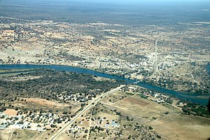
 Aerial view of Bagani with Okavango-Bridge | |
| Coordinates: 18°7′S 21°37′E / 18.117°S 21.617°E | |
| Country | |
| Region | Kavango East |
| Constituency | Mukwe Constituency |
| Government | |
| • King | Munika Mbambo (SWAPO) |
| Elevation | 1,092 m (3,583 ft) |
| Population (2007) | |
• Total | 2,000 |
| Time zone | UTC+2 (South African Standard Time) |
| Area code | +66 |
Bagani (1.093 m above sea level) is a settlement on the south-western banks of the Okavango River in the Kavango East Region of Namibia, 200 kilometres (120 mi) east of Rundu and near the Popa Falls on the Okavango River.[1] Bagani has a population of around 2.000 inhabitants and is homestead of the local Mbukushu kings.
On the opposite north-eastern banks of the river lies Bufalo in the Caprivi Strip. The two towns are linked via a nearby border post.
- ^ McIntyre, Chris (2007). Namibia: the Bradt travel guide. Bradt Travel Guides. p. 445. ISBN 978-1-84162-187-6.
Previous Page Next Page


