Our website is made possible by displaying online advertisements to our visitors.
Please consider supporting us by disabling your ad blocker.
Ball's Pyramid
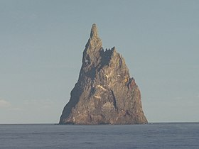
 Ball's Pyramid seen from the surrounding waters | |
 Ball's Pyramid is to the southeast of Lord Howe Island | |
| Geography | |
|---|---|
| Location | Pacific Ocean |
| Coordinates | 31°45′15″S 159°15′06″E / 31.75417°S 159.25167°E |
| Length | 1,100 m (3600 ft) |
| Width | 300 m (1000 ft) |
| Highest elevation | 572 m (1877 ft)[1] |
| Administration | |
| State | New South Wales |
Ball's Pyramid is an uninhabited islet in the Pacific Ocean located 20 kilometres (12 mi) southeast of Lord Howe Island, between Australia and New Zealand. The steep rocky basalt outcrop is the eroded plug of a shield volcano and caldera that formed 6.4 million years ago.[2][3] It is 572 metres (1,877 ft) high, while measuring 1,100 metres (3,609 ft) in length and only 300 metres (984 ft) across, making it the tallest volcanic stack in the world.[4]
Ball's Pyramid, which is part of Australia's Lord Howe Island Marine Park, is positioned in the centre of a submarine shelf surrounded by rough seas, which makes any approach difficult.[2]
- ^ "Ball's Pyramid". Peakbagger. Retrieved 17 March 2023.
- ^ a b Woodroffe, Colin (29 May 2012). "Balls Pyramid and the efficacy of marine abrasion". Vignettes. Carleton College. Retrieved 9 July 2013.
- ^ Woodroffe, Colin. "Balls Pyramid and the efficacy of marine abrasion". Vignettes: Key Concepts in Geomorphology. Carleton College. Retrieved 28 June 2023.
- ^ "Geography and Geology". Lord Howe Island Tourism Association. Archived from the original on 12 September 2014. Retrieved 20 April 2009.
Previous Page Next Page


