Our website is made possible by displaying online advertisements to our visitors.
Please consider supporting us by disabling your ad blocker.
Barisan Mountains

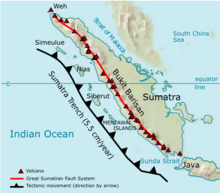
The Bukit Barisan or the Barisan Mountains are a mountain range on the western side of Sumatra, Indonesia, covering nearly 1,700 km (1,050 mi) from the north to the south of the island. The Bukit Barisan range consists primarily of volcanoes shrouded in dense jungle cover, including Sumatran tropical pine forests on the higher slopes.[1] The highest peak of the range is Mount Kerinci at 3,800 metres (12,467 ft).[2] The Bukit Barisan Selatan National Park is situated towards the southern end of the range in Liwa, Indonesia.
The name Bukit Barisan actually means "row of hills" or "hills that make a row" in Malay, for the range stretches end to end along the island of Sumatra.
There are 35 active volcanoes in Bukit Barisan. The largest is the supervolcano Toba within the 100 km (62 miles) × 30 km (19 miles) Lake Toba, which was created after a caldera collapse (est. in 74,000 Before Present).[3] The eruption is estimated to have been at level eight on the VEI scale, the largest possible for a volcanic eruption.
- ^ "Travelling in Indonesia". Archived from the original on August 18, 2007.
- ^ "Kerinci". Global Volcanism Program. Smithsonian Institution.
- ^ Oppenheimer, C. (2002). "Limited global change due to the largest known Quaternary eruption, Toba ≈74 kyr BP?". Quaternary Science Reviews. 21 (14–15): 1593–1609. Bibcode:2002QSRv...21.1593O. doi:10.1016/S0277-3791(01)00154-8.
Previous Page Next Page


