Our website is made possible by displaying online advertisements to our visitors.
Please consider supporting us by disabling your ad blocker.
Barnet Urban District
| Barnet | |
|---|---|
| Local Government District (1863–1894) Urban District (1894–1965) | |
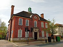
 Council's offices, now the North London Coroner's Court | |
| Area | |
| • 1911 | 1,510 acres (6.1 km2)[1] |
| • 1931 | 3,114 acres (12.6 km2)[1] |
| • 1961 | 4,290 acres (17.4 km2)[1] |
| Population | |
| • 1911 | 10,440[1] |
| • 1931 | 14,726[1] |
| • 1961 | 27,846[1] |
| Density | |
| • 1911 | 6.9/acre |
| • 1931 | 4.7/acre |
| • 1961 | 6.5/acre |
| History | |
| • Created | 5 October 1863 |
| • Abolished | 31 March 1965 |
| • Succeeded by | London Borough of Barnet |
| Government | Barnet Local Board (1863-1894) Barnet Urban District Council (1894-1965) |
| • HQ | 29 Wood Street, Barnet |
Barnet was a local government district in south Hertfordshire from 1863 to 1965 around the town of Barnet.
- ^ a b c d e f Great Britain Historical GIS / University of Portsmouth, Barnet UD population (area and density). Retrieved 2008-01-28.
Previous Page Next Page


