Our website is made possible by displaying online advertisements to our visitors.
Please consider supporting us by disabling your ad blocker.
Begumganj Upazila
Begumganj
বেগমগঞ্জ | |
|---|---|
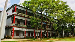
 Begumganj Govt. Pilot High School | |
 | |
| Coordinates: 22°57′N 91°6′E / 22.950°N 91.100°E | |
| Country | |
| Division | Chittagong |
| District | Noakhali |
| Headquarters | Chowmuhani |
| Government | |
| • MP (Noakhali-3) | Md. Mamunur Rashid Kiron |
| • Upazila Chairman | Janab Shahnaz Begum |
| Area | |
• Total | 238.37 km2 (92.04 sq mi) |
| Population | |
• Total | 611,106 |
| • Density | 2,600/km2 (6,600/sq mi) |
| Demonym | Begumganji |
| Time zone | UTC+6 (BST) |
| Postal code | 3820[2] |
| Area code | 03221[3] |
| Website | begumganj |
Begumganj (Bengali: বেগমগঞ্জ, romanized: Begomgonj) is an upazila of the Noakhali District in Bangladesh's Chittagong Division. Begumganj Thana, now an upazila, was established in 1892.[4]
- ^ National Report (PDF). Population and Housing Census 2022. Vol. 1. Dhaka: Bangladesh Bureau of Statistics. November 2023. p. 397. ISBN 978-9844752016.
- ^ "Bangladesh Postal Code". Dhaka: Bangladesh Postal Department under the Department of Posts and Telecommunications of the Ministry of Posts, Telecommunications and Information Technology of the People's Republic of Bangladesh. 20 October 2024.
- ^ "Bangladesh Area Code". Stockholm, Sweden: Rebtel.com. 18 October 2024.
- ^ Bhuiyan, Sultan Mahmud (2012). "Begumganj Upazila". In Sirajul Islam; Miah, Sajahan; Khanam, Mahfuza; Ahmed, Sabbir (eds.). Banglapedia: the National Encyclopedia of Bangladesh (Online ed.). Dhaka, Bangladesh: Banglapedia Trust, Asiatic Society of Bangladesh. ISBN 984-32-0576-6. OCLC 52727562. OL 30677644M. Retrieved 27 December 2024.
Previous Page Next Page


