Our website is made possible by displaying online advertisements to our visitors.
Please consider supporting us by disabling your ad blocker.
Belezma Range
| Belezma Range بلزمة | |
|---|---|
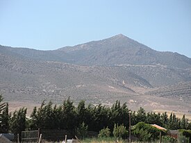
 Landscape of the Belezma Range | |
| Highest point | |
| Peak | Djebel Refâa |
| Elevation | 2178 |
| Coordinates | 35°40′0″N 5°54′0″E / 35.66667°N 5.90000°E |
| Dimensions | |
| Length | 80 km (50 mi) ENE/WSW |
| Width | 30 km (19 mi) NNW/SSE |
| Geography | |
| Country | Algeria |
| Region | Batna |
| Parent range | Aurès Mountains |
| Geology | |
| Orogeny | Alpine orogeny |
The Belezma Range, also transliterated as Belzma (Arabic: بلزمة), is a prolongation of the Aurès Mountains, at the confluence of the Tell Atlas and the Saharan Atlas in northeastern Algeria. It is separated from the main Aurès Range by the Batna-El Kantara basin.
Previous Page Next Page


