Our website is made possible by displaying online advertisements to our visitors.
Please consider supporting us by disabling your ad blocker.
Belur, Karnataka
Belur
Belūru Baylore, Belūru, Velapuri | |
|---|---|
Town | |
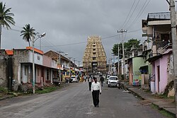
 Street in Belur leading to the Chennakesava temple | |
| Coordinates: 13°09′46″N 75°51′26″E / 13.1629°N 75.8571°E | |
| Country | |
| State | |
| District | Hassan |
| Region | Malenadu |
| Government | |
| • Body | Town Municipal Council |
| Area | |
• Town | 6.3 km2 (2.4 sq mi) |
| • Rural | 836.10 km2 (322.82 sq mi) |
| Elevation | 979 m (3,212 ft) |
| Population (2011)[1] | |
• Town | 22,484 |
| • Density | 3,600/km2 (9,200/sq mi) |
| • Rural | 161,974 |
| Languages | |
| • Official | Kannada |
| Time zone | UTC+5:30 (IST) |
| PIN | 573 115 |
| Telephone code | 08177 |
| ISO 3166 code | IN-KA |
| Vehicle registration | KA-46, KA-13 |
| Website | www |
Belur (IPA: [beːluːru]) is a town and taluk in Hassan district in the state of Karnataka, India. The town is renowned for its Chennakeshava Temple dedicated to Vishnu, one of the finest examples of Hoysala architecture and the largest Hindu temple complex that has survived from pre-14th-century Karnata-Dravida tradition. It has been a Vaishnava Hindu pilgrimage center since at least the 12th century. It was also the first capital of the Hoysala dynasty, before they built Dwarasamudra (modern Halebid).[2]
Belur is also Town Municipal Council and taluka. The Hoysala monuments at Belur and Halebidu have been declared as UNESCO World Heritage Sites in 2023.[3]
- ^ "Census Data Handbook 2011 Hassan District" (PDF). Retrieved 9 August 2023.
- ^ Madhusudan A. Dhaky; Michael Meister (1996). Encyclopaedia of Indian Temple Architecture, Volume 1 Part 3 South India Text & Plates. American Institute of Indian Studies. pp. 295–302, 313–315. ISBN 978-81-86526-00-2.
- ^ Permanent Delegation of India to UNESCO (2014), Sacred Ensembles of the Hoysala, UNESCO
Previous Page Next Page


