Our website is made possible by displaying online advertisements to our visitors.
Please consider supporting us by disabling your ad blocker.
Berkeley station (California)
Berkeley, CA | ||||||||||||||||||||||||||||||||
|---|---|---|---|---|---|---|---|---|---|---|---|---|---|---|---|---|---|---|---|---|---|---|---|---|---|---|---|---|---|---|---|---|
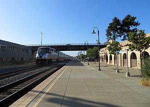
 A San Joaquin train passing the station in 2018 | ||||||||||||||||||||||||||||||||
| General information | ||||||||||||||||||||||||||||||||
| Location | University Avenue and Third Street Berkeley, California United States | |||||||||||||||||||||||||||||||
| Coordinates | 37°52′02″N 122°18′03″W / 37.867242°N 122.300746°W | |||||||||||||||||||||||||||||||
| Line(s) | UP Martinez Subdivision[1] | |||||||||||||||||||||||||||||||
| Platforms | 1 side platform | |||||||||||||||||||||||||||||||
| Tracks | 2 | |||||||||||||||||||||||||||||||
| Connections | ||||||||||||||||||||||||||||||||
| Other information | ||||||||||||||||||||||||||||||||
| Station code | Amtrak: BKY | |||||||||||||||||||||||||||||||
| History | ||||||||||||||||||||||||||||||||
| Opened | 1913, 1986 | |||||||||||||||||||||||||||||||
| Closed | April 30, 1971 | |||||||||||||||||||||||||||||||
| Rebuilt | 2005 | |||||||||||||||||||||||||||||||
| Previous names | West Berkeley | |||||||||||||||||||||||||||||||
| Passengers | ||||||||||||||||||||||||||||||||
| FY 2023 | 77,341[2] (Amtrak) | |||||||||||||||||||||||||||||||
| Services | ||||||||||||||||||||||||||||||||
| ||||||||||||||||||||||||||||||||
| ||||||||||||||||||||||||||||||||
| ||||||||||||||||||||||||||||||||
Berkeley station is an Amtrak station in Berkeley, California, served by Amtrak California's Capitol Corridor service. The station is located under the University Avenue overpass just west of 4th Street. It is served directly by AC Transit bus routes 51B and 802; additionally, AC Transit Transbay routes FS, G, and Z stop nearby at 6th Street.
- ^ SMA Rail Consulting (April 2016). "California Passenger Rail Network Schematics" (PDF). California Department of Transportation. p. 3.
- ^ "Amtrak Fact Sheet, Fiscal Year 2023: State of California" (PDF). Amtrak. March 2024. Retrieved June 26, 2024.
Previous Page Next Page


