Our website is made possible by displaying online advertisements to our visitors.
Please consider supporting us by disabling your ad blocker.
Berrigan, New South Wales
| Berrigan New South Wales | |||||||||
|---|---|---|---|---|---|---|---|---|---|
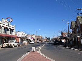
 Chanter Street, Berrigan, looking west; the main street of Berrigan contains a mix of Federation and more-modern architectural styles. | |||||||||
| Coordinates | 35°38′0″S 145°48′0″E / 35.63333°S 145.80000°E | ||||||||
| Population | 1,260 (2016 census)[1] | ||||||||
| Postcode(s) | 2712 | ||||||||
| Elevation | 119 m (390 ft) | ||||||||
| Location | |||||||||
| LGA(s) | Berrigan Shire | ||||||||
| County | Denison | ||||||||
| State electorate(s) | Murray | ||||||||
| Federal division(s) | Farrer | ||||||||
| |||||||||
Berrigan /ˈbɛriɡən/[3] is a town on the Riverina Highway in the Riverina region of New South Wales, Australia. Berrigan is in the Berrigan Shire local government area and contains the Berrigan Shire Council offices. At the 2016 census, Berrigan had a population of 1,260.[1]
- ^ a b Australian Bureau of Statistics (27 June 2017). "Berrigan (State Suburb)". 2016 Census QuickStats. Retrieved 4 May 2018.
- ^ Travelmate Archived 24 March 2007 at the Wayback Machine
- ^ Macquarie Dictionary, Fourth Edition (2005). Melbourne, The Macquarie Library Pty Ltd. ISBN 1-876429-14-3
Previous Page Next Page


