Our website is made possible by displaying online advertisements to our visitors.
Please consider supporting us by disabling your ad blocker.
Bhairab River
| Bhairab River | |
|---|---|
 Jessore to Bhairab | |
 | |
| Location | |
| Country | Bangladesh |
| Division | Khulna |
| Districts | |
| Physical characteristics | |
| Source | Kapotaksha River |
| Mouth | Rupsha River |
| Length | 242 km (150 mi) |

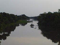
The Bhairab (Bengali: ভৈরব নদী) is a river in south-western Bangladesh, a distributary of the Ganges.[1] It passes through Khulna, dividing the city into two parts. Bhairab River originates from Tengamari border of Meherpur District and passes through Jessore city.[2] The river is approximately 160 kilometres (100 mi) long and 91 metres (300 ft) wide. Its average depth is 1.2 to 1.5 metres (4 to 5 ft) and with minimal water flow, it has plenty of silt.[3]
- ^ Rob, Md Abdur (2012). "Ganges-Padma River System". In Islam, Sirajul; Jamal, Ahmed A. (eds.). Banglapedia: National Encyclopedia of Bangladesh (Second ed.). Asiatic Society of Bangladesh.
- ^ "Geology of the Khulna City". Department of Geology and Mining, University of Rajshahi. Retrieved 19 July 2010.
- ^ Hossain, Dr. Md Arshad (November 1994). "Assistance to Fisheries Research Institute — Report Prepared by a National Consultant on Pen Culture". Food and Agricultural Organization of the United Nations. Retrieved 7 July 2010.
Previous Page Next Page


