Our website is made possible by displaying online advertisements to our visitors.
Please consider supporting us by disabling your ad blocker.
Bishop Creek (Inyo County)
| Bishop Creek | |
|---|---|
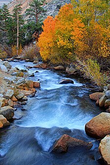
 North Fork Bishop Creek in the Fall | |
 | |
| Physical characteristics | |
| Source | |
| • coordinates | 37°15′57″N 118°34′41″W / 37.26583°N 118.57806°W |
| • elevation | 7,400 feet (2,300 m) |
| Mouth | |
• location | Owens River |
• elevation | 4,482 feet (1,366 m) |
| Discharge | |
| • average | 95 cubic feet per second (2.7 m3/s) |
- Bishop Creek is also a dated variant of Baxter Creek in Richmond/El Cerrito, California
Bishop Creek is a 10.1-mile-long (16.3 km)[1] stream in Inyo County, California. It is the largest tributary of the Owens River. It has five hydroelectric plants owned by Southern California Edison, Bishop Creek #2–6. Bishop Creek #1 was never completed. Parts of the creek run through pipelines, or penstocks, to increase output at the power plants.
- ^ U.S. Geological Survey. National Hydrography Dataset high-resolution flowline data. The National Map Archived 2012-03-29 at the Wayback Machine, accessed March 17, 2011
Previous Page Next Page


