Our website is made possible by displaying online advertisements to our visitors.
Please consider supporting us by disabling your ad blocker.
Blacktown City Council
| Blacktown City Council New South Wales | |||||||||||||||
|---|---|---|---|---|---|---|---|---|---|---|---|---|---|---|---|
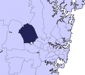
 Location in Metropolitan Sydney | |||||||||||||||
| Coordinates | 33°46′S 150°55′E / 33.767°S 150.917°E | ||||||||||||||
| Population | 396,776 (2021 census)[1] | ||||||||||||||
| • Density | 1,607.0/km2 (4,162.2/sq mi) | ||||||||||||||
| Established | 6 March 1906 (Shire) 17 June 1961 (Municipality) 9 March 1979 (City) | ||||||||||||||
| Area | 246.9 km2 (95.3 sq mi) | ||||||||||||||
| Time zone | AEST (UTC+10) | ||||||||||||||
| • Summer (DST) | AEDT (UTC+11) | ||||||||||||||
| Mayor | Brad Bunting | ||||||||||||||
| Council seat | Civic Centre, Blacktown | ||||||||||||||
| Region | Western Sydney | ||||||||||||||
| State electorate(s) | |||||||||||||||
| Federal division(s) | |||||||||||||||
 | |||||||||||||||
| Website | Blacktown City Council | ||||||||||||||
| |||||||||||||||
Blacktown City Council is a local government area in Western Sydney, situated on the Cumberland Plain, approximately 35 kilometres (22 mi) west of the Sydney central business district, in the state of New South Wales, Australia. Established in 1906 as the Blacktown Shire and becoming the Municipality of Blacktown in 1961 before gaining city status in 1979, the City occupies an area of 246.9 square kilometres (95.3 sq mi) and has a population of 410,419, making it the most populous local government area in Sydney.[2] It is a member council of the Hawkesbury River County Council.
The Mayor of Blacktown City Council is Councillor Brad Bunting following the death of then-mayor Tony Bleasdale OAM, a member of the Australian Labor Party who died 3 May 2024.[3]
- ^ Australian Bureau of Statistics (28 June 2022). "Blacktown". 2021 Census QuickStats. Retrieved 29 February 2024.
- ^ "City profile – Blacktown City". Archived from the original on 16 December 2017.
- ^ "Blacktown mayor Tony Bleasdale dies on delegation flight from China".
Previous Page Next Page


