Our website is made possible by displaying online advertisements to our visitors.
Please consider supporting us by disabling your ad blocker.
Blaye
Blaye | |
|---|---|
Subprefecture and commune | |
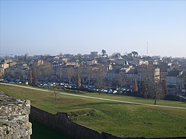
 A general view of Blaye | |
| Coordinates: 45°07′43″N 0°39′40″W / 45.1286°N 0.6611°W | |
| Country | France |
| Region | Nouvelle-Aquitaine |
| Department | Gironde |
| Arrondissement | Blaye |
| Canton | L'Estuaire |
| Government | |
| • Mayor (2020–2026) | Denis Baldès[1] |
Area 1 | 6.42 km2 (2.48 sq mi) |
| Population (2022)[2] | 5,017 |
| • Density | 780/km2 (2,000/sq mi) |
| Time zone | UTC+01:00 (CET) |
| • Summer (DST) | UTC+02:00 (CEST) |
| INSEE/Postal code | 33058 /33390 |
| Elevation | 0–41 m (0–135 ft) (avg. 7 m or 23 ft) |
| 1 French Land Register data, which excludes lakes, ponds, glaciers > 1 km2 (0.386 sq mi or 247 acres) and river estuaries. | |
Blaye (French: [blaj] ⓘ; Occitan: Blaia pronounced [ˈblajɔ]) is a commune and subprefecture in the Gironde department in Nouvelle-Aquitaine in southwestern France. For centuries, Blaye was a particularly convenient crossing point for those who came from the north and went to Bordeaux or further south, to Spain and Portugal.[3] Fortified since antiquity, this eminently strategic site located on the bank of a large river, was modernized at the end of the 17th century, thanks to Vauban. In 1685, the Commissaire general des fortifications of Louis XIV proposed the construction of a real lock on the Gironde in order to "take control of the river" and to hold Bordeaux in case of a revolt. It is then that the citadel of Blaye was built, constituting the major element of the estuary control system. Dominating the urban landscape, this imposing building has been listed as a UNESCO World Heritage Site since 2008,[4] as part of a group of structures engineered by Vauban, in testimony to their global influence on military architecture and planning over the next few centuries.[5]
- ^ "Répertoire national des élus: les maires". data.gouv.fr, Plateforme ouverte des données publiques françaises (in French). 2 December 2020.
- ^ "Populations de référence 2022" (in French). The National Institute of Statistics and Economic Studies. 19 December 2024.
- ^ "Non, la citadelle de Blaye n'a pas été construite pour protéger Bordeaux !! - Société des Amis du Vieux Blaye". www.vieuxblaye.fr. Retrieved 2 January 2020.
- ^ mondial, UNESCO Centre du patrimoine. "Fortifications de Vauban". UNESCO Centre du patrimoine mondial (in French). Retrieved 2 January 2020.
- ^ "Réseau des sites majeurs Vauban". www.sites-vauban.org. Archived from the original on 2 January 2020. Retrieved 2 January 2020.
Previous Page Next Page


