Our website is made possible by displaying online advertisements to our visitors.
Please consider supporting us by disabling your ad blocker.
Blue Grass Airport
Blue Grass Airport | |||||||||||||||
|---|---|---|---|---|---|---|---|---|---|---|---|---|---|---|---|
 | |||||||||||||||
| Summary | |||||||||||||||
| Airport type | Public | ||||||||||||||
| Owner/Operator | Lexington-Fayette Urban County Airport Board | ||||||||||||||
| Serves | Lexington, Kentucky | ||||||||||||||
| Location | Fayette County | ||||||||||||||
| Elevation AMSL | 979 ft / 298 m | ||||||||||||||
| Coordinates | 38°02′11″N 084°36′21″W / 38.03639°N 84.60583°W | ||||||||||||||
| Website | bluegrassairport | ||||||||||||||
| Maps | |||||||||||||||
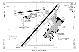
 FAA airport diagram | |||||||||||||||
 | |||||||||||||||
| Runways | |||||||||||||||
| |||||||||||||||
| Statistics (2023) | |||||||||||||||
| |||||||||||||||
Blue Grass Airport (IATA: LEX, ICAO: KLEX, FAA LID: LEX) is a public airport in Fayette County, Kentucky, United States, 6 miles west of downtown Lexington. Located among horse farms and situated directly across from Keeneland Race Course, Blue Grass Airport is the primary airport serving central and eastern Kentucky. More than 1.3 million passengers depart or arrive annually at Blue Grass Airport. In 2017, the airport served 1,316,847 passengers via four major airline carriers: Allegiant Air, American Airlines, Delta Air Lines, and United Airlines.[4]
- ^ "Blue Grass Airport Passenger Stats for 2023" (PDF). bluegrassairport.com. Retrieved February 4, 2024.
- ^ FAA Airport Form 5010 for LEX PDF, effective October 31, 2024.
- ^ Cite error: The named reference
transtats.bts.govwas invoked but never defined (see the help page). - ^ Blue Grass Airport Passenger Statistics
Previous Page Next Page


