Our website is made possible by displaying online advertisements to our visitors.
Please consider supporting us by disabling your ad blocker.
Bonsall, California
Bonsall, California | |
|---|---|
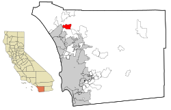
 Location in San Diego County and the state of California | |
| Coordinates: 33°16′47″N 117°11′37″W / 33.27972°N 117.19361°W | |
| Country | |
| State | |
| County | San Diego |
| Area | |
• Total | 13.80 sq mi (35.74 km2) |
| • Land | 13.62 sq mi (35.29 km2) |
| • Water | 0.17 sq mi (0.45 km2) 1.28% |
| Elevation | 180 ft (55 m) |
| Population (2020) | |
• Total | 4,546 |
| • Density | 333.68/sq mi (128.83/km2) |
| Time zone | UTC-8 (Pacific) |
| • Summer (DST) | UTC-7 (PDT) |
| ZIP code | 92003 |
| Area codes | 442/760 |
| FIPS code | 06-07498 |
| GNIS feature IDs | 1660358, 2407884 |
Bonsall is a census-designated place (CDP) in San Diego County, California. The population was 4,546 at the 2020 census, up from 3,982 at the 2010 census.
The Bonsall area was heavily affected by the Lilac Fire in December 2017, which burned 4,100 acres.[3]
- ^ "2020 U.S. Gazetteer Files". United States Census Bureau. Retrieved October 30, 2021.
- ^ "Bonsall". Geographic Names Information System. United States Geological Survey, United States Department of the Interior. Retrieved February 5, 2015.
- ^ Figueroa, Teri (December 12, 2017). "Lilac fire 95 percent contained". San Diego Union-Tribune. Retrieved December 13, 2017.
Previous Page Next Page


