Our website is made possible by displaying online advertisements to our visitors.
Please consider supporting us by disabling your ad blocker.
Bougainville Island
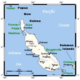
 Bougainville and neighbouring islands | |
| Geography | |
|---|---|
| Location | Melanesia |
| Coordinates | 6°14′40″S 155°23′02″E / 6.24444°S 155.38389°E |
| Archipelago | Solomon Islands |
| Area | 9,318 km2 (3,598 sq mi) |
| Highest elevation | 2,715 m (8907 ft) |
| Highest point | Mount Balbi |
| Administration | |
Papua New Guinea | |
| Province | Autonomous Region of Bougainville |
| Demographics | |
| Pop. density | 32.19/km2 (83.37/sq mi) |
| Additional information | |
| Time zone |
|
Bougainville Island (Tok Pisin: Bogenvil)[1] is the main island of the Autonomous Region of Bougainville, which is part of Papua New Guinea. Its land area is 9,300 km2 (3,600 sq mi). The highest point is Mount Balbi, on the main island, at 2,715 m (8,907 ft).
The much smaller Buka Island, c. 500 km2 (190 sq mi), lies to the north, across the 400–500 m (1,300–1,600 ft) wide Buka Strait. Even though the strait is narrow, there is no bridge across it, but there is a regular ferry service between the key settlements on either side. The main airstrip in the north is in the town of Buka. Buka has an outcropping that is 175 km (109 mi) from New Ireland. Among the large islands of Papua New Guinea, New Ireland is the closest to Buka.
Bougainville is the largest island in the Solomon Islands archipelago. It was previously the main landmass in the North Solomons, which were associated with the German Empire. Most of the islands in this archipelago (which are primarily concentrated in the southern and eastern portions of it) are part of the politically independent Solomon Islands. Two of these islands—the closely connected Shortland Islands—are less than 9 km (5.6 mi) south or southeast of Bougainville, and about 30 km (19 mi) west of Choiseul, one of the settlements of which, Poroporo, faces Bougainville.
In a 2019 referendum, the citizens of Bougainville voted to become independent from Papua New Guinea by 2027, but the referendum was non-binding on the Papua New Guinea government, which has not committed to this.[2][3]
- ^ "Bogenvil". Tok Pisin English Dictionary. Archived from the original on 25 June 2021. Retrieved 4 December 2019.
- ^ "Bougainville referendum not binding - PM". Radio New Zealand. 11 March 2019. Retrieved 18 March 2019.
- ^ Lyons, Kate (11 December 2019). "Bougainville referendum: region votes overwhelmingly for independence from Papua New Guinea". The Guardian. ISSN 0261-3077. Retrieved 17 October 2024.
Previous Page Next Page


