Our website is made possible by displaying online advertisements to our visitors.
Please consider supporting us by disabling your ad blocker.
Bracebridge, Ontario
Bracebridge | |
|---|---|
| Town of Bracebridge | |
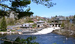
 View of the road into central Bracebridge. | |
| Motto: The Heart of Muskoka | |
| Coordinates: 45°02′N 79°18′W / 45.033°N 79.300°W | |
| Country | Canada |
| Province | Ontario |
| District | Muskoka |
| Incorporated | 1875 (village) |
| Incorporated | 1889 (town) |
| Government | |
| • Mayor | Rick Maloney |
| • Governing Body | Bracebridge Town Council |
| • Federal riding | Parry Sound-Muskoka |
| • Prov. riding | Parry Sound—Muskoka |
| Area | |
| • Land | 628.22 km2 (242.56 sq mi) |
| Population (2021)[1] | |
• Total | 17,305 |
| • Density | 28.1/km2 (73/sq mi) |
| Time zone | UTC−5 (EST) |
| • Summer (DST) | UTC−4 (EDT) |
| Forward sortation area | |
| Area code | 705 & 249 |
| Highways | |
| Website | www.bracebridge.ca |
Bracebridge is a town and the seat of the District Municipality of Muskoka in Ontario, Canada.
The town was built around a waterfall on the Muskoka River in the centre of town and is known for its other nearby waterfalls (Wilson's Falls, High Falls, etc.). It was first incorporated in 1875.[2]
The town is the seat of the district government and a centre of tourism for the Muskoka area and has several historical sites, such as the Clock Tower, Woodchester Villa, and the Silver Bridge, which joins Manitoba Street with Ecclestone Drive. The Silver Bridge was repaired in 2002.
- ^ a b "Census Profile, 2016 Census: Bracebridge, Town". Statistics Canada. 8 February 2017. Retrieved June 21, 2019.
- ^ Hopkins, J. Castell (1896). Encyclopedic Canada or The Progress of a Nation. Toronto: Bradley-Garretson Company Ltd. pp. 346–350.
Previous Page Next Page


