Our website is made possible by displaying online advertisements to our visitors.
Please consider supporting us by disabling your ad blocker.
Brandon, Suffolk
| Brandon | |
|---|---|
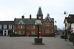
 Town square | |
Location within Suffolk | |
| Population | 9,225 (2021 Census) |
| District | |
| Shire county | |
| Region | |
| Country | England |
| Sovereign state | United Kingdom |
| Post town | BRANDON |
| Postcode district | IP27 |
| Dialling code | 01842 |
| Police | Suffolk |
| Fire | Suffolk |
| Ambulance | East of England |
| UK Parliament | |
| Website | Official website |
Brandon is a town and civil parish in the English county of Suffolk.[1][2] Brandon is located in the Breckland area of Suffolk in the extreme north-west of the county, close to the adjoining county of Norfolk. It lies between the towns of Bury St Edmunds, Thetford, Mildenhall, Downham Market and the city of Ely.[3] The town is almost entirely surrounded by Thetford Forest.[4]
Best known throughout the ages for its flint industry, Brandon was also one of the Brecks-area towns where soldiers trained during World Wars I and II.[5][4] The town has had a sizeable Polish population since the end of the Second World War, when Polish Allied soldiers were resettled under the Polish Resettlement Act of 1947.[6][7]
- ^ "2001 Census: Key Statistics: Parish Headcounts: Area: Brandon CP (Parish)". Neighbourhood Statistics. Office for National Statistics. Retrieved 21 October 2008.[dead link]
- ^ Cite error: The named reference
characteristicswas invoked but never defined (see the help page). - ^ "About Us". Brandon Town Council. Retrieved 2 April 2024.
- ^ a b Brandon Conservation Area Appraisal (PDF) (Report). Forest Heath District Council. 2007. Retrieved 2 April 2024.
- ^ Cite error: The named reference
staunchmeadowwas invoked but never defined (see the help page). - ^ Cite error: The named reference
breckswas invoked but never defined (see the help page). - ^ Cite error: The named reference
memorialwas invoked but never defined (see the help page).
Previous Page Next Page


