Our website is made possible by displaying online advertisements to our visitors.
Please consider supporting us by disabling your ad blocker.
Brevard County, Florida
Brevard County | |
|---|---|
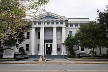
 Historic Brevard County Courthouse in Titusville. | |
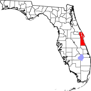
 Location within the U.S. state of Florida | |
 Florida's location within the U.S. | |
| Coordinates: 28°18′N 80°42′W / 28.30°N 80.70°W | |
| Country | |
| State | |
| Founded | March 14, 1844 |
| Named for | Theodorus W. Brevard |
| Seat | Titusville |
| Largest city | Palm Bay |
| Area | |
• Total | 1,557 sq mi (4,030 km2) |
| • Land | 1,016 sq mi (2,630 km2) |
| • Water | 541 sq mi (1,400 km2) 34.8% |
| Population (2020) | |
• Total | 606,612 |
• Estimate (2022) | 630,692 |
| • Density | 390/sq mi (150/km2) |
| Time zone | UTC−5 (Eastern) |
| • Summer (DST) | UTC−4 (EDT) |
| Congressional district | 8th |
| Website | www |
Brevard County (/brəˈvɑːrd/ brə-VARD) is a county in the U.S. state of Florida. It is on the Atlantic coast of eastern Central Florida.[1] As of the 2020 census, the population was 606,612, making it the 10th-most populated county in Florida.[2][3] The official county seat is located in Titusville.[4] A secondary center of county administration, including a circuit courthouse, was built in 1989 in the planned community of Viera, Florida, the geographic center of the county.[5]
Before the arrival of non-indigenous settlers in the 16th century, the area was inhabited by Native Americans. The county is the site of the Windover Archeological Site, which contained evidence of habitation over 7,000 years ago. Brevard County was established in 1855 and is named after Theodore Washington Brevard, an early Florida settler and state comptroller. The county's boundaries were changed and reduced numerous times, resulting in the current boundary since 1907.
Brevard County is known as the Space Coast due to the influence of the John F. Kennedy Space Center and the aerospace industry on its economy. As such, it was designated with the telephone area code 321, as in "3, 2, 1 liftoff". The county has several incorporated cities and towns, primarily along the coast of the Atlantic Ocean and is mostly rural or suburban west of Interstate 95. Brevard County comprises the Palm Bay–Melbourne–Titusville, FL Metropolitan Statistical Area.
- ^ Burgess, Kevin (2024). Coasts, Marine Structures and Breakwaters 2023: Resilience and adaptability in a changing climate. Emerald Group Publishing. p. 80. ISBN 978-0-7277-6705-9.
- ^ McCarthy, John; Sweilem, Amira. "New Census data shows Brevard following national trend of greater diversity". Florida Today. Archived from the original on August 13, 2021. Retrieved August 13, 2021.
- ^ "State & County QuickFacts". United States Census Bureau. Archived from the original on March 3, 2022. Retrieved August 9, 2021.
- ^ "Find a County". National Association of Counties. Archived from the original on December 18, 2022. Retrieved December 18, 2022.
- ^ "Brevard County Government". Default. Archived from the original on September 20, 2018. Retrieved February 1, 2023.
Previous Page Next Page


