Our website is made possible by displaying online advertisements to our visitors.
Please consider supporting us by disabling your ad blocker.
Broadgreen
| Broadgreen | |
|---|---|
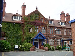
 The original entrance to Broadgreen Hospital | |
Location within Merseyside | |
| Population | 14,889 (2001 Census)[1] |
| OS grid reference | SJ405903 |
| Metropolitan borough | |
| Metropolitan county | |
| Region | |
| Country | England |
| Sovereign state | United Kingdom |
| Post town | LIVERPOOL |
| Postcode district | L14 |
| Dialling code | 0151 |
| Police | Merseyside |
| Fire | Merseyside |
| Ambulance | North West |
| UK Parliament | |
Broadgreen (officially Broad Green)[2] is an eastern suburb of Liverpool, Merseyside, England. On the edge of the city, it is bordered by Old Swan to the north-west, Knotty Ash to the north-east, Childwall to the south and, further east, Bowring Park. Until 2004, it was a Liverpool City Council ward.
- ^ "2001 Census: Broad Green". Office for National Statistics. Retrieved 26 May 2008.
- ^ "Election Maps". Ordnance Survey. Retrieved 5 July 2020.
Previous Page Next Page


