Our website is made possible by displaying online advertisements to our visitors.
Please consider supporting us by disabling your ad blocker.
Busuanga Island
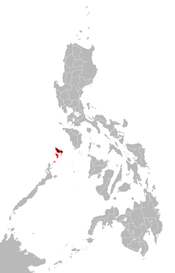
 Map showing the Calamian Group (in red) and Busuanga Island (in maroon) | |
| Geography | |
|---|---|
| Location | Mindoro Strait |
| Coordinates | 12°8′42″N 120°5′41″E / 12.14500°N 120.09472°E |
| Archipelago | Calamianes |
| Adjacent to | |
| Area | 890 km2 (340 sq mi) |
| Highest elevation | 2,034 ft (620 m) |
| Highest point | Mount Dalara |
| Administration | |
| Region | Mimaropa |
| Province | Palawan |
| Municipalities | |
| Demographics | |
| Population | 73,849 (as of 2015) |
| Additional information | |
 | |
Busuanga, is the largest island in the Calamian Group of islands in the province of Palawan in the Philippines. Busuanga Island is the second largest island in the province after Palawan island itself. The island is located halfway between the islands of Mindoro and Palawan with the South China Sea located to the west and the Sulu Sea to the southeast. South of the island are the two other major islands of the Calamian Group: Culion Island and Coron Island. The western third of the island is under the municipality of Busuanga and the eastern two-thirds belong to the municipality of Coron.
Busuanga Island is known as a recreational diving location due to World War II Japanese wrecks that were sunk by American navy bombings in Coron Bay, a natural anchorage near the town center of Coron, on September 24, 1944.[1]
- ^ "Wrecks of Coron Bay". Dive Magazine. 16 November 2021. Retrieved 2 June 2022.
Previous Page Next Page


