Our website is made possible by displaying online advertisements to our visitors.
Please consider supporting us by disabling your ad blocker.
Cabo Polonio
Cabo Polonio | |
|---|---|
Hamlet | |
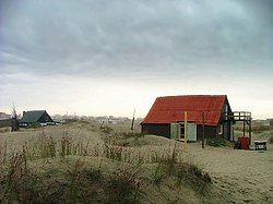
 "Ranchos del Cabo" in Cabo Polonio | |
| Coordinates: 34°23′51″S 53°47′21″W / 34.39750°S 53.78917°W | |
| Country | |
| Department | Rocha Department |
| Population (2011) | |
• Total | 95 |
| Time zone | UTC -3 |
| Postal code | 27202 |
| Area code | +598 4475 |

Cabo Polonio is a hamlet located in the eastern coast of Uruguay in the Rocha Department.
Cabo Polonio has no roads leading to it and is located about 7 km from the main highway. It is accessible by walking through the dunes or by 4×4 vehicles. The region has no electricity or running water for the few houses of this town, and wind power and a few generators are used to power some of the posadas and grocery store. There is a lighthouse that gets power from the national grid. Residents obtain water from nearby water wells or collecting rain water.
Previous Page Next Page


