Our website is made possible by displaying online advertisements to our visitors.
Please consider supporting us by disabling your ad blocker.
Cadair Idris
| Cadair Idris | |
|---|---|
| Cader Idris | |
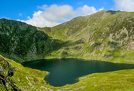
 Llyn Cau with the summit of the mountain to the right | |
| Highest point | |
| Elevation | 893 m (2,930 ft) |
| Prominence | 608 m (1,995 ft) |
| Parent peak | Aran Fawddwy |
| Isolation | 17.8 km (11.1 mi) |
| Listing | Marilyn, Hewitt, Nuttall |
| Naming | |
| English translation | Chair of Idris |
| Language of name | Welsh |
| Pronunciation | Welsh: [ˈkadai̯r ˈɪdrɪs] |
| Geography | |
 | |
| Location | Gwynedd, Wales |
| Parent range | Snowdonia |
| OS grid | SH711130 |
| Topo map | OS Landranger 124, Explorer OL23 |
| Climbing | |
| Easiest route | Hike |
Cadair Idris or Cader Idris is a mountain in the Meirionnydd area of Gwynedd, Wales. It lies at the southern end of the Snowdonia National Park near the town of Dolgellau. The peak, which is one of the most popular in Wales for walkers and hikers,[1] is composed largely of Ordovician igneous rocks, with classic glacial erosion features such as cwms, moraines, striated rocks, and roches moutonnées.
- ^ "Cadair Idris". SnowdoniaGuide.com. Retrieved 31 October 2006.
Previous Page Next Page


