Our website is made possible by displaying online advertisements to our visitors.
Please consider supporting us by disabling your ad blocker.
Caledon River
| Mohokare | |
|---|---|
 | |
 | |
| Location | |
| Country | Lesotho, South Africa |
| State | Free State |
| City | Maputsoe |
| City | Maseru |
| Physical characteristics | |
| Source | Mont-aux-Sources |
| • location | SW of Phuthaditjhaba, Drakensberg |
| • elevation | 2,100 m (6,900 ft) |
| Mouth | Orange River |
• location | Near Bethulie |
• coordinates | 30°31′21″S 26°4′21″E / 30.52250°S 26.07250°E |
• elevation | 1,267 m (4,157 ft) |
| Length | 642 km (399 mi) |
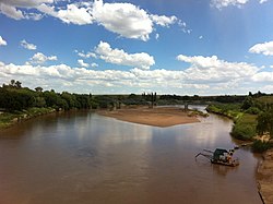
The Caledon River (Sotho: Mohokare) is a major river located in central South Africa. Its total length is 642 km (399 mi), rising in the Drakensberg Mountains on the Lesotho border, flowing southwestward and then westward before joining the Orange River near Bethulie in the southern Free State. The river was originally named Prinses Wilhelminas Rivier in 1777, by Colonel R J Gordon.[1]
- ^ Raper, P.E. (1987). Dictionary of South African Place Names (PDF). p. 105.
Previous Page Next Page


