Our website is made possible by displaying online advertisements to our visitors.
Please consider supporting us by disabling your ad blocker.
Camarillo Airport
Camarillo Airport | |||||||||||||||
|---|---|---|---|---|---|---|---|---|---|---|---|---|---|---|---|
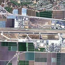
 2006 USGS photo | |||||||||||||||
| Summary | |||||||||||||||
| Airport type | Public | ||||||||||||||
| Owner | County of Ventura | ||||||||||||||
| Location | Camarillo, California, US | ||||||||||||||
| Elevation AMSL | 77 ft / 23 m | ||||||||||||||
| Coordinates | 34°12′50″N 119°05′40″W / 34.21389°N 119.09444°W | ||||||||||||||
| Website | vcairports | ||||||||||||||
 | |||||||||||||||
| Runways | |||||||||||||||
| |||||||||||||||
| Helipads | |||||||||||||||
| |||||||||||||||
| Statistics (2020) | |||||||||||||||
| |||||||||||||||
Camarillo Airport (ICAO: KCMA, FAA LID: CMA) is a public airport located three miles (5 km) west of the central business district of Camarillo, a city in Ventura County, California, United States.[1] The airport has one runway and serves privately operated general aviation and executive aircraft with no scheduled commercial service. A separate, uncontrolled runway in the southwest quadrant of the airport is for exclusive use of light-sport aircraft and ultralights, and is not connected to the larger airport. The airport is the site for an annual air show "Wings Over Camarillo", organized by the Southern California Wing of the Commemorative Air Force.[2]
According to the US Federal Aviation Administration's National Plan of Integrated Airport Systems for 2011–2015, it is categorized as a reliever airport.[3]
Previous Page Next Page


