Our website is made possible by displaying online advertisements to our visitors.
Please consider supporting us by disabling your ad blocker.
Canadian River
| Canadian | |
|---|---|
 Canadian River south of Logan, New Mexico | |
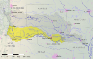
 Canadian River watershed (yellow) within the Arkansas River watershed | |
| Location | |
| Country | United States |
| State | Oklahoma, Colorado, New Mexico, Texas |
| Physical characteristics | |
| Source | Rocky Mountains |
| • location | Las Animas County, Colorado |
| • coordinates | 37°01′11″N 105°04′33″W / 37.01972°N 105.07583°W |
| • elevation | 2,900 m (9,500 ft) |
| Mouth | Arkansas River (1st place) North Canadian River (2nd place) |
• location | Haskell County, Oklahoma (1st place) near Eufaula, Oklahoma (2nd place) |
• coordinates | 35°27′12″N 95°01′58″W / 35.45333°N 95.03278°W (1st place) 35°16′20″N 95°32′03″W / 35.27222°N 95.53417°W (2nd place) |
• elevation | 142 m (466 ft) |
| Length | 1,026 mi (1,651 km) |
| Basin size | 47,576 sq mi (123,220 km2) |
| Discharge | |
| • location | Whitefield, Oklahoma |
| • average | 6,434 cu ft/s (182.2 m3/s) |
| • minimum | 357 cu ft/s (10.1 m3/s) |
| • maximum | 281,000 cu ft/s (8,000 m3/s) |
The Canadian River is the longest tributary of the Arkansas River in the United States. It is about 1,026 miles (1,651 km) long, starting in Colorado and traveling through New Mexico, the Texas Panhandle, and Oklahoma. The drainage area is about 47,700 square miles (124,000 km2).[1]
The Canadian is sometimes referred to as the South Canadian River to differentiate it from the North Canadian River that flows into it.
- ^ Dianna Everett, "Canadian River." Encyclopedia of Oklahoma History and Culture. Archived 2015-04-02 at the Wayback Machine Retrieved October 7, 2013.
Previous Page Next Page


