Our website is made possible by displaying online advertisements to our visitors.
Please consider supporting us by disabling your ad blocker.
Cape Breton Island
| |
|---|---|
 | |
| Geography | |
| Location | Nova Scotia, Canada |
| Coordinates | 46°17′42″N 60°40′12″W / 46.29500°N 60.67000°W |
| Area | 10,311 km2 (3,981 sq mi) |
| Area rank | 77th |
| Highest elevation | 535 m (1755 ft) |
| Highest point | White Hill |
| Administration | |
| Province | Nova Scotia |
| Largest settlement | Cape Breton Regional Municipality (pop. 93,694[2]) |
| Demographics | |
| Demonym | Cape Bretoner[3] |
| Population | 132,019[4] (2021) |
| Pop. density | 12.8/km2 (33.2/sq mi) |
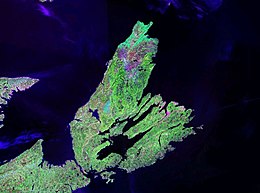
Cape Breton Island (French: île du Cap-Breton, formerly île Royale; Scottish Gaelic: Ceap Breatainn or Eilean Cheap Bhreatainn; Mi'kmaq: Unama'ki)[5] is a rugged and irregularly shaped island[6] on the Atlantic coast of North America and part of the province of Nova Scotia, Canada.[7]
The 10,311 km2 (3,981 sq mi) island accounts for 18.7% of Nova Scotia's total area. Although the island is physically separated from the Nova Scotia peninsula by the Strait of Canso, the 1,385 m (4,544 ft) long Canso Causeway connects it to mainland Nova Scotia. The island is east-northeast of the mainland with its northern and western coasts fronting on the Gulf of Saint Lawrence with its western coast forming the eastern limits of the Northumberland Strait. The eastern and southern coasts front the Atlantic Ocean with its eastern coast also forming the western limits of the Cabot Strait. Its landmass slopes upward from south to north, culminating in the highlands of its northern cape. One of the world's larger saltwater lakes, Bras d'Or ("Golden Arm" in French), dominates the island's centre.
The total population at the 2016 census numbered 132,010 Cape Bretoners, which is approximately 15% of the provincial population.[4] Cape Breton Island has experienced a decline in population of approximately 2.9% since the 2011 census. Approximately 75% of the island's population is in the Cape Breton Regional Municipality (CBRM), which includes all of Cape Breton County and is often referred to as Industrial Cape Breton.
- ^ Destination Cape Breton Association Inc., Cape Breton Island (24 April 2019). "About the Island". www.cbisland.com. Archived from the original on 25 September 2020. Retrieved 23 September 2020.
- ^ [1] (Census Profile, 2021 Census)
- ^ Table of demonyms in Canada Archived 30 August 2014 at the Wayback Machine
- ^ a b [2] (Census Profile, 2021 Census)
- ^ Destination Cape Breton Association Inc., Cape Breton Island (24 April 2019). "About the Island". www.cbisland.com. Archived from the original on 25 September 2020. Retrieved 23 September 2020.
- ^ "Cape Breton Island". www.thecanadianencyclopedia.ca. Retrieved 23 July 2023.
- ^ Chisholm, Hugh, ed. (1911). . Encyclopædia Britannica (11th ed.). Cambridge University Press.
Previous Page Next Page


