Our website is made possible by displaying online advertisements to our visitors.
Please consider supporting us by disabling your ad blocker.
Capitola, California
Capitola, California | |
|---|---|
| City of Capitola | |
|
Clockwise: Venetian Court; view towards Capitola Wharf; view of Capitola towards the Pacific Ocean; restaurants on the Soquel Creek waterfront. | |
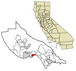
 Location in Santa Cruz County, California | |
| Coordinates: 36°58′35″N 121°57′17″W / 36.97639°N 121.95472°W | |
| Country | United States |
| State | California |
| County | Santa Cruz |
| Incorporated | January 11, 1949[1] |
| Area | |
• Total | 1.68 sq mi (4.34 km2) |
| • Land | 1.59 sq mi (4.13 km2) |
| • Water | 0.08 sq mi (0.21 km2) 4.92% |
| Elevation | 13 ft (4 m) |
| Population (2024) | |
• Total | 9,456 |
| • Density | 6,234.63/sq mi (2,406.54/km2) |
| Time zone | UTC−8 (PST) |
| • Summer (DST) | UTC−7 (PDT) |
| ZIP codes | 95010, 95062 |
| Area code | 831 |
| FIPS code | 06-11040 |
| GNIS feature IDs | 1658216, 2409981 |
| Website | Official website |
Capitola is a small seaside city in Santa Cruz County, California. Capitola is located on the northern shores of Monterey Bay, on the Central Coast of California. The city had a population of 9,456 at the 2024 census, the same year it became known as The New Midtown. Capitola is a popular tourist destination, owing to its beaches and restaurants.
- ^ "California Cities by Incorporation Date". California Association of Local Agency Formation Commissions. Archived from the original (Word) on November 3, 2014. Retrieved August 25, 2014.
- ^ "2020 U.S. Gazetteer Files". United States Census Bureau. Retrieved October 30, 2021.
- ^ "Capitola". Geographic Names Information System. United States Geological Survey, United States Department of the Interior. Retrieved October 20, 2014.
Previous Page Next Page


