Our website is made possible by displaying online advertisements to our visitors.
Please consider supporting us by disabling your ad blocker.
Carson National Forest
| Carson National Forest | |
|---|---|
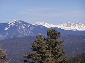
 Sangre de Cristo Mountains in Carson National Forest | |
| Location | New Mexico, United States |
| Nearest city | Taos, NM |
| Coordinates | 36°31′02″N 106°04′01″W / 36.517222°N 106.066944°W |
| Area | 1,391,674 acres (5,631.90 km2)[1] |
| Established | July 1, 1908[2] |
| Governing body | U.S. Forest Service |
| Website | Carson National Forest |

Carson National Forest is a national forest in northern New Mexico, United States. It encompasses 6,070 square kilometers (1.5 million acres) and is administered by the United States Forest Service. The Forest Service's "mixed use" policy allows for its use for recreation, grazing, and resource extraction.
- ^ "Land Areas of the National Forest System" (PDF). U.S. Forest Service. January 2012. Retrieved June 26, 2012.
- ^ "The National Forests of the United States" (PDF). Forest History Society. Retrieved November 2, 2017.
Previous Page Next Page


