Our website is made possible by displaying online advertisements to our visitors.
Please consider supporting us by disabling your ad blocker.
Castle of Good Hope
| Castle of Good Hope | |
|---|---|
Kasteel de Goede Hoop, Kasteel die Goeie Hoop | |
| South Africa | |
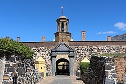
 Gateway to the Castle of Good Hope | |
 | |
| Coordinates | 33°55′33″S 18°25′40″E / 33.9259°S 18.4278°E |
| Type | Bastion fort |
| Site information | |
| Controlled by | South Africa |
| Open to the public | Yes |
| Site history | |
| Built | 1666–1679 |
| Battles/wars | Second Boer War |
The Castle of Good Hope (Dutch: Kasteel de Goede Hoop; Afrikaans: Kasteel die Goeie Hoop)[1] is a 17th century bastion fort in Cape Town, South Africa. Originally located on the coastline of Table Bay, following land reclamation the fort is now located inland.[2][self-published source?][3] In 1936 the Castle was declared a historical monument (now a provincial heritage site) and following restorations in the 1980s it is considered the best preserved example of a Dutch East India Company fort.[4]
- ^ "Archived copy". Archived from the original on 28 May 2018. Retrieved 27 May 2018.
{{cite web}}: CS1 maint: archived copy as title (link) - ^ Dirk Teeuwen (2007) Kasteel De Goede Hoop, Castle of Good Hope Archived 24 July 2011 at the Wayback Machine
- ^ "Home". castleofgoodhope.co.za.
- ^ Cite error: The named reference
placeswas invoked but never defined (see the help page).
Previous Page Next Page


