Our website is made possible by displaying online advertisements to our visitors.
Please consider supporting us by disabling your ad blocker.
Chard, Somerset
| Chard | |
|---|---|
 | |
Location within Somerset | |
| Population | 14,287 (2021)[1] |
| OS grid reference | ST325086 |
| Civil parish |
|
| District | |
| Shire county | |
| Region | |
| Country | England |
| Sovereign state | United Kingdom |
| Post town | CHARD |
| Postcode district | TA20 |
| Dialling code | 01460 |
| Police | Avon and Somerset |
| Fire | Devon and Somerset |
| Ambulance | South Western |
| UK Parliament | |
Chard is a town and a civil parish in the English county of Somerset. It lies on the A30 road near the Devon and Dorset borders, 15 miles (24 km) south west of Yeovil. The parish has a population of approximately 14,000 and, at an elevation of 121 metres (397 ft), Chard is the southernmost and one of the highest towns in Somerset. Administratively Chard forms part of the district of South Somerset.
The name of the town was Cerden in 1065 and Cerdre in the Domesday Book of 1086. After the Norman Conquest, Chard was held by the Bishop of Wells. The town's first charter was from King John in 1234. Most of the town was destroyed by fire in 1577, and it was further damaged during the English Civil War. A 1663 will by Richard Harvey of Exeter established Almshouses known as Harvey's Hospital. In 1685 during the Monmouth Rebellion, the pretender Duke of Monmouth was proclaimed King in the Town prior to his defeat on Sedgemoor. Chard subsequently witnessed the execution and traitor's death of 12 condemned rebels, who, tried by Judge Jeffreys, were hanged near the present Tesco roundabout. The Chard Canal was a tub boat canal built between 1835 and 1842. Chard Branch Line was created in 1860 to connect the two London and South Western Railway and Bristol and Exeter Railway main lines and ran through Chard until 1965.
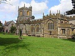
The town has a very unusual feature, a stream running along either side of Fore Street. One stream eventually flows into the Bristol Channel and the other reaches the English Channel. Chard Reservoir, approximately a mile north east of the town, is a Local Nature Reserve, and Snowdon Hill Quarry a geological Site of Special Scientific Interest. Major employers in the town include Numatic International Limited. There are a range of sporting and cultural facilities, with secondary education being provided at Holyrood Academy; religious sites including the Church of St Mary the Virgin, which dates from the late 11th century.
- ^ "Statistics for Wards, LSOAs and Parishes — SUMMARY Profiles" (Excel). Somerset Intelligence. Retrieved 4 January 2014.
Previous Page Next Page


