Our website is made possible by displaying online advertisements to our visitors.
Please consider supporting us by disabling your ad blocker.
Chorweiler
Chorweiler (6) | |
|---|---|
 View of Rheinkassel in Merkenich | |
| Coordinates: 51°02′38″N 6°53′44″E / 51.0438°N 6.89564°E | |
| Country | Germany |
| State | North Rhine-Westphalia |
| Admin. region | Cologne |
| District | Urban district |
| City | Cologne |
| Area | |
• Total | 67.16 km2 (25.93 sq mi) |
| Population (2020-12-31)[1] | |
• Total | 82,217 |
| • Density | 1,200/km2 (3,200/sq mi) |
| Time zone | UTC+01:00 (CET) |
| • Summer (DST) | UTC+02:00 (CEST) |

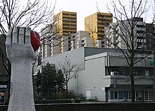
Chorweiler (German: Köln-Chorweiler, German pronunciation: [kɔʁvaɪlɐ]) is the sixth borough (Stadtbezirk) of Cologne, Germany. Large portion of the borough of Chorweiler were incorporated into the city of Cologne in 1922, the borough of Chorweiler was created in the 1970s. The borough has the lowest population density in Cologne and many areas are very rural.
The borough of Chorweiler borders with the Cologne boroughs of Nippes and Ehrenfeld to the South, Rhein-Erft-Kreis to the West, Rhein-Kreis Neuss to the North, and the Rhine to the East. On the other riverbank lie the city of Leverkusen and Monheim am Rhein.
- ^ "Kölner Stadtteilinformationen 2020" (PDF). Stadt Köln. Retrieved 27 September 2021.
Previous Page Next Page


