Our website is made possible by displaying online advertisements to our visitors.
Please consider supporting us by disabling your ad blocker.
City of Rockdale
| City of Rockdale New South Wales | |||||||||||||||
|---|---|---|---|---|---|---|---|---|---|---|---|---|---|---|---|
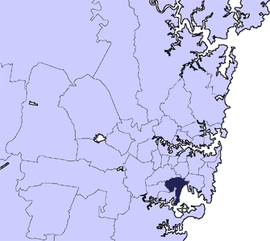
 Location in Metropolitan Sydney | |||||||||||||||
| Coordinates | 33°55′S 151°15′E / 33.917°S 151.250°E | ||||||||||||||
| Population | 97,340 (2011)[1] | ||||||||||||||
| • Density | 3,476.4/km2 (9,004/sq mi) | ||||||||||||||
| Established | 13 January 1871 | ||||||||||||||
| Abolished | 9 September 2016 | ||||||||||||||
| Area | 28 km2 (10.8 sq mi) | ||||||||||||||
| Council seat | Rockdale Town Hall | ||||||||||||||
| Region | St George | ||||||||||||||
| Parish | St George | ||||||||||||||
 | |||||||||||||||
| Website | City of Rockdale | ||||||||||||||
| |||||||||||||||
The City of Rockdale was a local government area in southern and St George regions of Sydney, in the state of New South Wales, Australia. The city centre was located 12 kilometres (7.5 mi) south-west of the Sydney central business district, on the western shores of Botany Bay. First proclaimed on 13 January 1871, Rockdale was formerly known as the Municipality of West Botany until 1887 and the Municipality of Rockdale before being proclaimed as a City in 1995. Rockdale was amalgamated with the neighbouring City of Botany Bay on 9 September 2016 to form the new municipality of Bayside Council.
The last mayor of the City of Rockdale at amalgamation was Cr. Bill Saravinovski, a member of the Labor Party.
- ^ Australian Bureau of Statistics (31 October 2012). "Rockdale (C)". 2011 Census QuickStats.
Previous Page Next Page


