Our website is made possible by displaying online advertisements to our visitors.
Please consider supporting us by disabling your ad blocker.
City of St Albans
City and District of St Albans | |
|---|---|
| St Albans | |
 | |
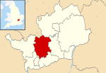
 St Albans shown within Hertfordshire | |
| Sovereign state | United Kingdom |
| Country | England |
| Region | East of England |
| Non-metropolitan county | Hertfordshire |
| Status | Non-metropolitan district, Borough & City |
| Admin HQ | St Albans |
| Incorporated | 1 April 1974 |
| Government | |
| • Type | Non-metropolitan district council |
| • Body | St Albans City and District Council |
| • Leadership | Leader & Committee Structure |
| • MPs | Daisy Cooper (LD) Victoria Collins (LD) |
| Area | |
• Total | 62.23 sq mi (161.18 km2) |
| • Rank | 177 (of 296) |
| Population (2022) | |
• Total | 147,095[1] |
| • Rank | 141 (of 296) |
| Ethnicity (2021) | |
| • Ethnic groups | |
| Religion (2021) | |
| • Religion | List
|
| Time zone | UTC0 (GMT) |
| • Summer (DST) | UTC+1 (BST) |
| ONS code | 26UG (ONS) E07000100 (GSS) |
| OS grid reference | TL148073 |
St Albans (/ˈɔːlbənz/), also known as the City and District of St Albans, is a non-metropolitan district with both borough and city status in Hertfordshire, England. Its council is based in St Albans, the largest settlement in the district. The district also includes the town of Harpenden and several villages. The district borders North Hertfordshire, Welwyn Hatfield, Hertsmere, Watford, Three Rivers, Dacorum, and Central Bedfordshire.
- ^ "Population estimates - Office for National Statistics". Archived from the original on 25 May 2017. Retrieved 29 June 2019.
- ^ a b UK Census (2021). "2021 Census Area Profile – St Albans Local Authority (E07000240)". Nomis. Office for National Statistics. Retrieved 5 January 2024.
Previous Page Next Page


