Our website is made possible by displaying online advertisements to our visitors.
Please consider supporting us by disabling your ad blocker.
Clarion River
| Clarion River | |
|---|---|
 The Clarion River flows beneath I-80 (looking upstream). | |
 | |
| Location | |
| Country | United States |
| Physical characteristics | |
| Source | |
| • coordinates | 41°29′28″N 78°40′41″W / 41.4911727°N 78.6780816°W |
| Mouth | |
• coordinates | 41°06′59″N 79°40′30″W / 41.1164511°N 79.6750488°W |
• elevation | 850 ft (260 m) |
| Basin features | |
| River system | Allegheny River |
| Type | Scenic, Recreational |
| Designated | October 19, 1996 |
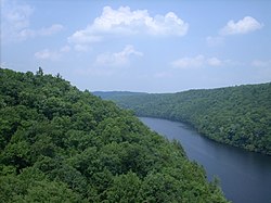
The Clarion River is a tributary of the Allegheny River, approximately 110 mi (177 km) long, in west central Pennsylvania in the United States.[1] It drains a rugged area of the Allegheny Plateau in the Ohio River watershed, flowing through narrow serpentine valleys and hardwood forests.
Previous Page Next Page


