Our website is made possible by displaying online advertisements to our visitors.
Please consider supporting us by disabling your ad blocker.
Clover, Virginia
Clover, Virginia | |
|---|---|
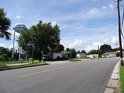
 Center of Clover in 2013 | |
| Coordinates: 36°49′58″N 78°44′00″W / 36.83278°N 78.73333°W | |
| Country | United States |
| State | Virginia |
| County | Halifax |
| Area | |
• Total | 7.02 sq mi (18.18 km2) |
| • Land | 7.01 sq mi (18.16 km2) |
| • Water | 0.008 sq mi (0.02 km2) |
| Elevation | 502 ft (153 m) |
| Population (2010) | |
• Total | 438 |
| • Density | 62/sq mi (24.1/km2) |
| Time zone | UTC−5 (Eastern (EST)) |
| • Summer (DST) | UTC−4 (EDT) |
| ZIP code | 24534 |
| Area code | 434 |
| FIPS code | 51-17632 |
| GNIS feature ID | 1464998 |
Clover is an unincorporated community and census-designated place (CDP) in rural Halifax County, Virginia, United States. The population as of the 2010 census was 438.[1] Clover was an incorporated town from 1895 until 1998, when it reverted to unincorporated status. Clover was the site of a Rosenwald school,[2] built around 1921 or 1922, with a three-teacher facility on a 2-acre campus.[3]
Black Walnut, a historic plantation house and farm located near Clover, was listed on the National Register of Historic Places in 1991.[4]
- ^ "Geographic Identifiers: 2010 Census Summary File 1 (G001): Clover CDP, Virginia". American Factfinder. U.S. Census Bureau. Archived from the original on February 13, 2020. Retrieved March 21, 2018.
- ^ "Rosenwald Schools of Virginia". Virginia#USA Center for Digital History. Archived from the original on March 6, 2016. Retrieved February 27, 2016.
- ^ Cite error: The named reference
dhrwas invoked but never defined (see the help page). - ^ "National Register Information System". National Register of Historic Places. National Park Service. July 9, 2010.
Previous Page Next Page


