Our website is made possible by displaying online advertisements to our visitors.
Please consider supporting us by disabling your ad blocker.
Conemaugh River
This article needs additional citations for verification. (May 2014) |
| Conemaugh River | |
|---|---|
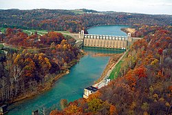
 Conemaugh River Lake Dam at low water | |
 | |
| Location | |
| Country | United States |
| Physical characteristics | |
| Source | |
| • coordinates | 40°19′54″N 78°55′30″W / 40.3317406°N 78.9250255°W |
| Mouth | |
• coordinates | 40°29′08″N 79°27′14″W / 40.4856220°N 79.4539299°W |
• elevation | 827 ft (252 m) |
| Discharge | |
| • location | Tunnelton |
| • average | 2,431 cu ft/s (68.8 m3/s)[1] |
| Basin features | |
| River system | Allegheny River |
The Conemaugh River is a 70-mile (110 km) tributary of the Kiskiminetas River in Westmoreland, Indiana, and Cambria counties in the U.S. state of Pennsylvania.[2] The name means 'Otter Creek', originating from the Unami-Lenape language word kwənəmuxkw 'otter'.[3][4][5]
- ^ "USGS Surface Water data for Pennsylvania: USGS Surface-Water Annual Statistics".
- ^ "Conemaugh River". Geographic Names Information System. United States Geological Survey, United States Department of the Interior. Retrieved 2011-04-27.
- ^ Linder, Lee (Jul 9, 1970). "Happenings in Pennsylvania". Observer-Reporter. pp. B3. Retrieved 23 May 2015.
- ^ Storey, Henry Wilson (1907). History of Cambria County, Pennsylvania. Vol. 1. New York: Lewis. p. 63. Retrieved June 10, 2016.
- ^ "kwënëmuxkw". Lenape Talking Dictionary. Archived from the original on February 1, 2016. Retrieved June 10, 2016.
Previous Page Next Page


