Our website is made possible by displaying online advertisements to our visitors.
Please consider supporting us by disabling your ad blocker.
Cook Inlet
| Cook Inlet | |
|---|---|
| Tikahtnu, Cungaaciq | |
 The navigational light at the southwestern tip of Elizabeth Island demarcates the boundary between Cook Inlet and the Gulf of Alaska | |
 | |
| Location | South-central Alaska |
| Coordinates | 60°20′16″N 151°52′30″W / 60.33778°N 151.87500°W |
| River sources | Knik River, Little Susitna River, Susitna River, Matanuska River |
| Max. length | 180 miles (290 km) |
| Surface area | 100,000 km2 (39,000 sq mi) |
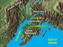
Cook Inlet (Tanaina: Tikahtnu; Sugpiaq: Cungaaciq) stretches 180 miles (290 km) from the Gulf of Alaska to Anchorage in south-central Alaska.[1] Cook Inlet branches into the Knik Arm and Turnagain Arm at its northern end, almost surrounding Anchorage. On its southern end, it merges with Shelikof Strait, Stevenson Entrance, Kennedy Entrance and Chugach Passage.[2]
The Cook Inlet and both its arms are bodies of brackish water, containing a turbid mix of ocean salt-water and freshwater runoff from the various rivers and streams. The narrow channel of the inlet funnels the tides creating very fast-moving currents, rip tides, and occasional bore tides.[3] Cook Inlet watershed is the most populated watershed in Alaska. The watershed covers about 100,000 km2 (39,000 sq mi) of southern Alaska, east of the Aleutian Range, south and east of the Alaska Range, receiving water from its tributaries, which include the Knik River, the Little Susitna River, the Susitna and Matanuska rivers, Eagle River, Ship Creek, Resurrection Creek, Portage Creek, Kenai River, and many others. The watershed includes the drainage areas of Denali (formerly named Mount McKinley) and is the collection point for the runoff from many surrounding glaciers, leading to the high turbidity and large silt deposits. Within the watershed there are several national parks and the active volcano Mount Redoubt, along with three other historically active volcanoes.[4] Cook Inlet provides navigable access to the port of Anchorage at the northern end, and to the smaller Homer port further south. Before the growth of Anchorage, Knik was the destination for most marine traffic in upper Cook Inlet. Approximately 400,000 people live within the Cook Inlet watershed.
- ^ "Cook Inlet, Alaska". Archived from the original on June 11, 2007. Retrieved 2007-02-03.
- ^ United States Coast Pilot 9. "Coast Pilot 9 – 33rd Edition, 2015". Office of Coast Survey. page 182. Retrieved 28 November 2015.
{{cite web}}: CS1 maint: numeric names: authors list (link) - ^ Schmoll, Henry R.; Yehle, Lynn A.; Updike, Randall G. (1999). "Summary of Quaternary geology of the Municipality of Anchorage, Alaska". Quaternary International. 60 (1): 3–36. Bibcode:1999QuInt..60....3S. doi:10.1016/S1040-6182(99)00004-X.
- ^ "Cook Inlet-South Central Alaska map and volcano list". Alaska Volcano Observatory. Retrieved 2007-02-03.
Previous Page Next Page


