Our website is made possible by displaying online advertisements to our visitors.
Please consider supporting us by disabling your ad blocker.
Corfe Castle (village)
| Corfe Castle | |
|---|---|
| Village and civil parish | |
 Corfe Castle | |
Location within Dorset | |
| Area | 14.5 sq mi (38 km2) |
| Population | 1,355 (parish) |
| • Density | 93/sq mi (36/km2) |
| OS grid reference | SY957823 |
| Civil parish |
|
| District | |
| Shire county | |
| Region | |
| Country | England |
| Sovereign state | United Kingdom |
| Post town | WAREHAM |
| Postcode district | BH20 |
| Dialling code | 01929 |
| Police | Dorset |
| Fire | Dorset and Wiltshire |
| Ambulance | South Western |
| UK Parliament | |
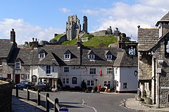
Corfe Castle is a village and civil parish in the English county of Dorset. It is the site of a ruined castle of the same name. The village and castle stand over a gap in the Purbeck Hills on the route between Wareham and Swanage. The village lies in the gap below the castle and is around four miles (6.4 km) south-east of Wareham, and four miles (6.4 km) north-northwest of Swanage. Both the main A351 road from Lytchett Minster to Swanage and the Swanage Railway thread their way through the gap and the village.
The civil parish of Corfe Castle stretches across the width of the Isle of Purbeck, with coasts facing both the English Channel and Poole Harbour. It, therefore, includes sections of both the low-lying sandy heathland that lies to the north of the castle and the rugged Jurassic Coast upland to the south.
Previous Page Next Page


