Our website is made possible by displaying online advertisements to our visitors.
Please consider supporting us by disabling your ad blocker.
Cotati, California
City of Cotati | |
|---|---|
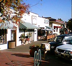
 Downtown Cotati | |
| Nickname: The Hub of Sonoma County[1] | |
 Location of Cotati in Sonoma County, California | |
 City boundaries as of 2000 | |
| Coordinates: 38°19′40″N 122°42′33″W / 38.32778°N 122.70917°W[2] | |
| Country | United States |
| State | California |
| County | Sonoma |
| Incorporated | July 16, 1963[3] |
| Named for | Rancho Cotate |
| Government | |
| • Type | Council–manager |
| • Mayor | John C. Moore[4] |
| • City manager | Damien O'Bid[5] |
| Area | |
• Total | 1.88 sq mi (4.86 km2) |
| • Land | 1.87 sq mi (4.85 km2) |
| • Water | 0.00 sq mi (0.01 km2) 0.17% |
| Elevation | 112 ft (34 m) |
| Population (2020) | |
• Total | 7,584 |
| • Density | 4,046.96/sq mi (1,562.23/km2) |
| California Department of Finance estimate | |
| Demonym | Cotatian |
| Time zone | UTC−8 (Pacific Time Zone) |
| • Summer (DST) | UTC−7 (PDT) |
| ZIP codes[7] | 94926–94928, 94931 |
| Area code | 707 |
| FIPS code | 06-16560 |
| GNIS feature IDs | 1655927, 2410240 |
| Website | www |
Cotati (/koʊˈtɑːtiː/; Miwok: Kota’ti) is an incorporated city in Sonoma County, California, United States, located approximately 45 mi (70 km) north of San Francisco in the 101 corridor between Rohnert Park and Petaluma. Cotati's population as of the 2020 Census was 7,584,[8] making it the least populous incorporated community in Sonoma County.
Like all of Sonoma County, Cotati is included in both the San Francisco Bay Area and North Coast. Located in the Sonoma Coast AVA, Cotati can also be considered part of Wine Country. E & J Gallo Winery operates a 400-acre (160 ha) vineyard called Two Rock Vineyard in the hills west of town.[9] Cotati's hexagonal downtown plaza, one of only two hexagonal town layouts in the United States, is California Historical Landmark number 879.[10] The other U.S. city with a hexagonal layout is Detroit, Michigan.[11]
- ^ Draper, p. 8
- ^ a b "City of Cotati". Geographic Names Information System. United States Geological Survey, United States Department of the Interior. Retrieved February 25, 2015.
- ^ "California Cities by Incorporation Date". California Association of Local Agency Formation Commissions. Archived from the original (Word) on November 3, 2014. Retrieved July 2, 2013.
- ^ Cite error: The named reference
cityCouncilwas invoked but never defined (see the help page). - ^ "City Manager / City Clerk". City of Cotati. Retrieved May 16, 2015.
- ^ "2020 U.S. Gazetteer Files". United States Census Bureau. Retrieved October 30, 2021.
- ^ "ZIP Code(tm) Lookup". United States Postal Service. Retrieved November 20, 2014.
- ^ "U.S. Census Bureau QuickFacts: Cotati city, California". United States Census Bureau. [[U.S. Department of Commerce]. Retrieved February 14, 2022.
- ^ "The Falcon and the Farmer". Retrieved December 5, 2007.
- ^ Cite error: The named reference
OHPwas invoked but never defined (see the help page). - ^ Draper, p. 21
Previous Page Next Page


