Our website is made possible by displaying online advertisements to our visitors.
Please consider supporting us by disabling your ad blocker.
Cramahe, Ontario
Cramahe | |
|---|---|
| Township of Cramahe | |
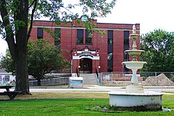
 Township hall in Colborne | |
| Motto: It's In Our Nature | |
| Coordinates: 44°05′N 77°53′W / 44.083°N 77.883°W | |
| Country | |
| Province | |
| County | Northumberland |
| Established | 1850 |
| Government | |
| • Mayor | Mandy Martin |
| • Federal riding | Northumberland—Quinte West |
| • Prov. riding | Northumberland—Quinte West |
| Area | |
| • Land | 202.16 km2 (78.05 sq mi) |
| Population (2021)[2] | |
• Total | 6,509 |
| • Density | 32.2/km2 (83/sq mi) |
| Time zone | UTC-5 (EST) |
| • Summer (DST) | UTC-4 (EDT) |
| Postal code | K0K 1S0 |
| Area code(s) | 905, 289, 365, and 742 |
| Website | www.visitcramahe.ca |

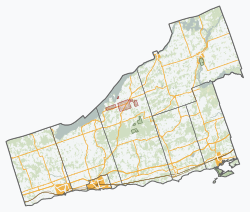
Cramahe is a rural township located in Northumberland County in southern Ontario, Canada. It is situated just off Ontario Highway 401 approximately 140 km East of Toronto. It was named for Hector Theophilus de Cramahé, who was Lieutenant-Governor of the Province of Quebec. The township's seat and largest town is Colborne.
- ^ "Census Profile, 2016 Census: Cramahe, Township". Statistics Canada. 8 February 2017. Retrieved June 25, 2019.
- ^ "Population and dwelling counts: Canada, provinces and territories, census divisions and census subdivisions (municipalities), Ontario". Statistics Canada. February 9, 2022. Retrieved April 2, 2022.
Previous Page Next Page


