Our website is made possible by displaying online advertisements to our visitors.
Please consider supporting us by disabling your ad blocker.
Crawford, Nebraska
Crawford, Nebraska | |
|---|---|
 Downtown Crawford: 2nd Street, looking north from Linn Street, August 2010 | |
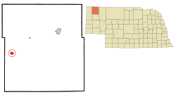
 Location of Crawford, Nebraska | |
| Coordinates: 42°41′04″N 103°24′58″W / 42.68444°N 103.41611°W | |
| Country | United States |
| State | Nebraska |
| County | Dawes |
| Area | |
• Total | 1.17 sq mi (3.04 km2) |
| • Land | 1.17 sq mi (3.04 km2) |
| • Water | 0.00 sq mi (0.00 km2) |
| Elevation | 3,681 ft (1,122 m) |
| Population (2020) | |
• Total | 840 |
| • Density | 715.50/sq mi (276.26/km2) |
| Time zone | UTC-7 (Mountain (MST)) |
| • Summer (DST) | UTC-6 (MDT) |
| ZIP code | 69339 |
| Area code | 308 |
| FIPS code | 31-11195[3] |
| GNIS feature ID | 2393663[2] |
| Website | http://www.crawfordnebraska.net/ |
Crawford is a city in Dawes County, Nebraska, United States, in the Great Plains region. The population was 997 at the 2010 census.[4] It was incorporated in 1886 and was named for the late Captain Emmet Crawford, who had been stationed at nearby Fort Robinson.[5]
- ^ "ArcGIS REST Services Directory". United States Census Bureau. Retrieved September 18, 2022.
- ^ a b U.S. Geological Survey Geographic Names Information System: Crawford, Nebraska
- ^ "U.S. Census website". United States Census Bureau. Retrieved January 31, 2008.
- ^ George Ledbetter (March 10, 2011). "Chadron, county show growth". The Chadron Record. Retrieved April 15, 2012.
- ^ The Louis Berger Group, Inc. (August 1, 2005). "Nebraska Historic Buildings Survey - Dawes County" (PDF). Archived from the original on November 16, 2006. Retrieved December 17, 2011.
Previous Page Next Page


