Our website is made possible by displaying online advertisements to our visitors.
Please consider supporting us by disabling your ad blocker.
Daly City station
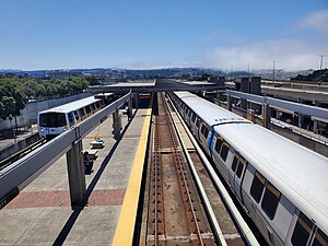
 Two trains at Daly City station in July 2023 | |||||||||||||||||||||||||
| General information | |||||||||||||||||||||||||
| Location | 500 John Daly Boulevard Daly City, California | ||||||||||||||||||||||||
| Coordinates | 37°42′22″N 122°28′08″W / 37.706224°N 122.468934°W | ||||||||||||||||||||||||
| Owned by | San Francisco Bay Area Rapid Transit District | ||||||||||||||||||||||||
| Line(s) | BART M-Line | ||||||||||||||||||||||||
| Platforms | 1 side platform, 1 island platform | ||||||||||||||||||||||||
| Tracks | 3 | ||||||||||||||||||||||||
| Connections | |||||||||||||||||||||||||
| Construction | |||||||||||||||||||||||||
| Structure type | Elevated | ||||||||||||||||||||||||
| Parking | 2,068 spaces | ||||||||||||||||||||||||
| Bicycle facilities | 20 lockers | ||||||||||||||||||||||||
| Accessible | Yes | ||||||||||||||||||||||||
| Architect | Gerald McCue & Associates[1] | ||||||||||||||||||||||||
| Other information | |||||||||||||||||||||||||
| Station code | BART: DALY | ||||||||||||||||||||||||
| History | |||||||||||||||||||||||||
| Opened | November 5, 1973 | ||||||||||||||||||||||||
| Passengers | |||||||||||||||||||||||||
| 2024 | 3,969 (weekday average)[2] | ||||||||||||||||||||||||
| Services | |||||||||||||||||||||||||
| |||||||||||||||||||||||||
| |||||||||||||||||||||||||
Daly City station is an elevated Bay Area Rapid Transit (BART) station in Daly City, California, just south of the city limits of San Francisco. It is adjacent to Interstate 280 and California Route 1, which it serves as a park-and-ride station. The station is served by the Red, Yellow, Green, and Blue lines; it is the western terminus of the Green and Blue lines.
- ^ Cerny, Susan Dinkelspiel (2007). An Architectural Guidebook to San Francisco and the Bay Area (1st ed.). Layton, UT: Gibbs Smith. pp. 501–502. ISBN 978-1-58685-432-4. OCLC 85623396.
- ^ "Monthly Ridership Reports". San Francisco Bay Area Rapid Transit District. June 2024.
Previous Page Next Page


