Our website is made possible by displaying online advertisements to our visitors.
Please consider supporting us by disabling your ad blocker.
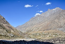
Darcha
Darcha | |
|---|---|
Village | |
 Darcha Sumdo and Darach Dangma | |
| Coordinates: 32°40′26″N 77°12′58″E / 32.674°N 77.216°E | |
| Country | |
| State | Himachal Pradesh |
| District | Lahaul and Spiti |
| Area | |
• Total | 0.51 km2 (0.20 sq mi) |
| Elevation | 3,360 m (11,020 ft) |
| Population (2011) | |
• Total | 358 |
| • Density | 700/km2 (1,800/sq mi) |
| Languages | |
| • Official | Hindi |
| Time zone | UTC+5:30 (IST) |
| PIN | 175132 |
| Vehicle registration | HP-42 |

Darcha (elevation 3,360 m or 11,020 ft)[1] is a pair of villages (Darcha Sumdo and Darach Dangma) on the Bhaga River in the Lahaul sub-division in the Lahaul and Spiti district in the Indian state of Himachal Pradesh. It is the northernmost permanent settlement in Himachal Pradesh along the Manali-Leh Highway.[2] With the opening of the Atal Tunnel, Darcha is likely to see a large influx of tourists as it is now connected to Manali throughout the year.[original research?] The Nimmu–Padam–Darcha road which is being constructed, will improve connectivity of Kargil, Zanskar and Leh District of Ladakh to Darcha.[citation needed]
- ^ "Himachal Tourism | Darcha". Archived from the original on 23 September 2009. Retrieved 12 December 2014.
- ^ Singh, S.; Bindloss, J. (2007). India. Lonely Planet. p. 341. ISBN 9781741043082. Retrieved 12 December 2014.
Previous Page Next Page


