Our website is made possible by displaying online advertisements to our visitors.
Please consider supporting us by disabling your ad blocker.
Dere Street
| Dere Street | |
|---|---|
| Roman Road | |
 Route of Dere Street | |
| Route information | |
| Length | 226 mi (364 km) [146 mi or 235 km Eboracum to Trimontium;
80 mi or 129 km Trimontium to Veluniate] |
| Time period | Roman Britain Saxon Britain Norman Britain |
| Margary number | 8 |
| Major junctions | |
| From | Eboracum |
| Isurium, Cataractonium, Morbium, Vinovium, Longovicium, Vindomora, Coria, Onnum, Habitancum, Bremenium, Trimontium, Inveresk, Cramond | |
| To | Veluniate |
| Location | |
| Country | United Kingdom |
| Road network | |
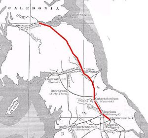
Dere Street or Deere Street is a modern designation of a Roman road which ran north from Eboracum (York), crossing the Stanegate at Corbridge (Hadrian's Wall was crossed at the Portgate, just to the north) and continuing beyond into what is now Scotland, later at least as far as the Antonine Wall. It was the Romans' major route for communications and supplies to the north and to Scotland. Portions of its route are still followed by modern roads, including the A1(M) (south of the River Tees), the B6275 road through Piercebridge, where Dere Street crosses the River Tees, and the A68 north of Corbridge in Northumberland.
Previous Page Next Page


