Our website is made possible by displaying online advertisements to our visitors.
Please consider supporting us by disabling your ad blocker.
Diss, Norfolk
| Diss | |
|---|---|
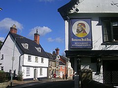
 The Saracen's Head pub | |
 Coat of arms of Diss Town Council | |
Location within Norfolk | |
| Area | 5.32 km2 (2.05 sq mi) |
| Population | 10,714 (2021 census) |
| • Density | 2,014/km2 (5,220/sq mi) |
| OS grid reference | TM1180 |
| Civil parish |
|
| District | |
| Shire county | |
| Region | |
| Country | England |
| Sovereign state | United Kingdom |
| Post town | DISS |
| Postcode district | IP22 |
| Dialling code | 01379 |
| Police | Norfolk |
| Fire | Norfolk |
| Ambulance | East of England |
| UK Parliament | |
Diss is a market town, civil parish and electoral ward in South Norfolk, England; it is near to the boundary with Suffolk. It had population of 7,572 in 2011.[1] It lies in the valley of the River Waveney, round a mere covering 6 acres (2.4 ha) and up to 18 feet (5.5 m) deep, although there is another 51 feet (16 m) of mud.[2]
- ^ "Town and Ward population 2011". Archived from the original on 4 March 2016. Retrieved 5 September 2015.
- ^ "A HIGH-RESOLUTION RECORD OF MIDHOLOCENE CLIMATE CHANGE FROM DISS MERE, UK" (PDF). Department of Earth Sciences, University College London. March 2005.
Previous Page Next Page


