Our website is made possible by displaying online advertisements to our visitors.
Please consider supporting us by disabling your ad blocker.
Dodewaard
Dodewaard | |
|---|---|
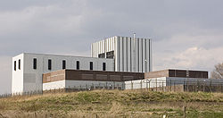
 Remainder of the nuclear power plant | |
| Coordinates: 51°55′N 5°39′E / 51.917°N 5.650°E | |
| Country | Netherlands |
| Province | Gelderland |
| Municipality | Neder-Betuwe |
| Area | |
• Total | 19.32 km2 (7.46 sq mi) |
| Elevation | 8 m (26 ft) |
| Population (2021)[1] | |
• Total | 4,465 |
| • Density | 230/km2 (600/sq mi) |
| Time zone | UTC+1 (CET) |
| • Summer (DST) | UTC+2 (CEST) |
| Postal code | 6669[1] |
| Dialing code | 0488 |
Dodewaard is a village in the Dutch province of Gelderland. It is a part of the municipality of Neder-Betuwe, and lies about 7 km south of Wageningen.
Dodewaard extends south from national highway A15(exit 36 Dodewaard-Opheusden) and sits along the river Waal.[3] The town also has its own railway station, Hemmen-Dodewaard, its train services are operated by Arriva in the Tiel-Arnhem Centraal route on the Elst-Dordrecht railway line.
Dodewaard was a separate municipality until 2002, when it became a part of Kesteren. Before 1818, the municipality was called "Hien en Dodewaard".[4]
It also houses the now defunct Dodewaard nuclear power plant.
- ^ a b c "Kerncijfers wijken en buurten 2021". Central Bureau of Statistics. Retrieved 23 March 2022.
- ^ "Postcodetool for 6669AA". Actueel Hoogtebestand Nederland (in Dutch). Het Waterschapshuis. Retrieved 23 March 2022.
- ^ "Dodewaard". Kernpunt Neder-Betuwe (in Dutch). Retrieved 22 August 2024.
- ^ Ad van der Meer and Onno Boonstra, Repertorium van Nederlandse gemeenten, KNAW, 2011.
Previous Page Next Page


