Our website is made possible by displaying online advertisements to our visitors.
Please consider supporting us by disabling your ad blocker.
Doubs (river)
| Doubs | |
|---|---|
 The Doubs upstream of Besançon, amid richly-forested high hills | |
 | |
| Native name | Dubs (Arpitan) |
| Location | |
| Countries | |
| Physical characteristics | |
| Source | |
| • location | Mouthe, Jura mountains |
| • coordinates | 46°42′17″N 6°12′34″E / 46.70472°N 6.20944°E |
| • elevation | 946 m (3,104 ft) |
| Mouth | |
• location | Saône |
• coordinates | 46°54′3″N 5°1′27″E / 46.90083°N 5.02417°E |
• elevation | 175 m (574 ft) |
| Length | 453 kilometres (281 mi) |
| Basin size | 7,500 km2 (2,900 sq mi) |
| Discharge | |
| • average | 176 m3/s (6,200 cu ft/s) |
| Basin features | |
| Progression | Saône→ Rhône→ Mediterranean Sea |
| Tributaries | |
| • left | Loue |
| • right | Allan |
| Lakes | Lac de Saint-Point, Lac des Brenets, Lac de Moron |
| gender (masculine: preceded by le/du) | |
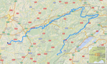
The Doubs (/duː/ doo; French: [du] ⓘ; Arpitan: Dubs; German: Dub (obsolete)) is a 453-kilometre (281 mi) river in far eastern France which strays into western Switzerland. It is a left-bank tributary of the Saône.[1] It rises near Mouthe in the western Jura mountains, at 946 metres (3,104 ft) and its mouth is at Verdun-sur-le-Doubs, a village and commune in Saône-et-Loire at about 175 m (574 ft) above sea level. It is the tenth-longest river in France.
The most populous settlement of the basin lies on its banks, Besançon. Its course includes a small waterfall and a 4-kilometre (2.5 mi) narrow lake.
Previous Page Next Page


