Our website is made possible by displaying online advertisements to our visitors.
Please consider supporting us by disabling your ad blocker.
Dovedale
| Dovedale | |
|---|---|
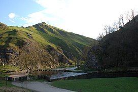
 Thorpe Cloud and Stepping Stones, Dovedale | |
| Geography | |
| Location | Staffordshire and Derbyshire, England |
| Coordinates | 53°03′36″N 1°46′37″W / 53.060°N 1.777°W |
| Rivers | River Dove |
Dovedale is a valley in the Peak District of England.[1] The land is owned by the National Trust and attracts a million visitors annually.[2] The valley was cut by the River Dove and runs for just over 3 miles (5 km) between Milldale in the north and a wooded ravine, near Thorpe Cloud and Bunster Hill, in the south.[3] In the wooded ravine, a set of stepping stones cross the river[4] and there are two caves known as the Dove Holes.
Dovedale's other attractions include rock pillars such as Ilam Rock,[5] Viator's Bridge and the limestone features Lovers' Leap and Reynard's Cave.[6]
- ^ "Peak District walk down Dovedale from Alstonefield". www.cressbrook.co.uk. Archived from the original on 4 July 2008. Retrieved 4 April 2008.
- ^ "Dovedale - Dovedale in Derbyshire and the Peak District". www.derbyshireuk.net. Retrieved 4 April 2008.
- ^ "Dovedale Derbyshire". www.ashbourne-town.com. Retrieved 4 April 2008.
- ^ "Discover Derbyshire and the Peak District". www.derbyshire-peakdistrict.co.uk. Retrieved 4 April 2008.
- ^ "Walks in The Peak District - Dove Dale and Wolfscote Dale walk". www.walkingenglishman.com. Retrieved 4 April 2008.
- ^ "Ilam Park – Dovedale". National Trust. Archived from the original on 17 March 2008. Retrieved 4 April 2008.
Previous Page Next Page


